navigation

Un exemple de carte des vents.

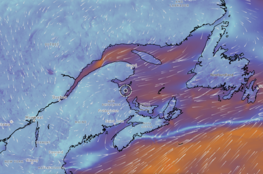
Nautical charts in real time

The St. Lawrence Global Observatory had been offering limited access to various S-100 map layers for some time. The Nautilo app extends these maps to a range of services designed for navigation. It includes real-time wind and current data, as well as tide forecasting tools.

Cinq applications électroniques de navigation.

A free electronic navigation course

Electronic apps are now an integral part of recreational boating. This course aims to help you understand how to use them, as well as their strengths and weaknesses. It includes three general texts on electronic charts and navigation apps. It then focuses on five popular navigation apps: Navionics (Boating), OpenCPN,...

Cinq applications électroniques de navigation.

Which Navigation App is Best for Me?

I have written five texts describing the use of the electronic navigation applications: Navionics (Boating), C-MAP, OpenCPN, Savvy Navvy and SeaIQ. Each text examines hot to perform eight essential navigation tasks. Which one is best suited to your needs? The table below assesses the strengths and weaknesses of each. Criteria...

Le port de Montréal avec son trafic.

Introduction to SEAiq – Pilot

Note: the author benefited from a licence from the Canadian Hydrographic Service and from SEAiq to write this text. This text is the last of five on electronic navigation applications. It covers the use of the SEAiq – Pilot software. This software enables you to work with S-100 charts, the...

Copie d'écran de l'application C-MAP.

Introduction to the C-MAP application

This is the third of five articles on the use of electronic navigation applications. It focuses on the C-MAP application. The other texts cover the use of OpenCPN, Savy Navy, Navionics and SEAiq. It focuses mainly on installations on tablets or cellular devices that are not connected to a sailboat’s...

Carte électronique de navigation (CEN).

Introduction to electronic charts

This text is intended as an introduction to electronic navigational charts (ENCs). It covers how they are designed. This knowledge helps understanding how to use them and their limitations. It is an essential reading before using our introduction to electronic navigation applications. You can also read a similar text on...

Navionics

Introduction to Navionics (Boating)

This text is the first in a series of five on electronic navigation applications. It shows you how to perform the most important navigation tasks, i.e. how to: This first text covers the Navionics (Boating) application. The other texts cover OpenCPN, Savyy Navy, C-MAP and SEAiq respectively. Prior to reading...

A Fast Rescue Craft

Fixing Techniques for Fast Boats

This text explains a fixing technique that is applicable on fast boats. It makes use of paper charts when there is little to no space for chartwork. The technique is useful if the chartplotter fails, or if checking the validity of an electronic fix is required. I learned the technique...

Spherical trigonometry and navigation

Setting the scene A ship leaves New York, USA, bound for Brest, France. Assuming it takes the shortest route, what will be its departure course? If it is sailing at 15 knots, how long will it take to reach Brest? The coordinates of the two ports are known (below). City...

Two special cases of navigation lights

This short text describes two particular cases of navigation lights that have come to my attention in recent days. Both are in situations of reduced visibility, or at night. I found the examples interesting because they reveal parts of the navigation lights conventions that are less well known. Three red...