Learning

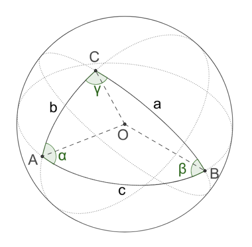
Spherical triangle exercices (with formulas)

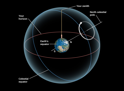
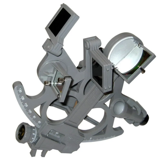
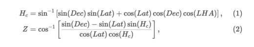
Here is a series of five reduction exercises based on sextant observations, using spherical trigonometry. To understand how to complete these exercises, you will need to have read the text on reducing sextant observations or, more generally, the series of texts on celestial navigation. Exercise 1 Your estimated position is...

Spherical Triangles and Sight Reduction

This text is the sixth in a series on celestial navigation. It focuses on the method for converting sextant readings into a position line, i.e. a reduction of sextant observations. The text explaining how to find the GP of a celestial body should be read beforehand. The reduction is the...

Finding the GP of a Celestial Body

In developing a theory of celestial navigation, we have seen that a ship’s position is determined using circles of position centred on the GP of a celestial body. This fifth article in the series on celestial navigation shows how to find the GP of any celestial body. This is an...

The theory of Astronavigation

This is the second in a series of articles on celestial navigation. It sets out the theory needed to understand how the technique works. The focus is on understanding, rather than calculation: we’re looking at the big picture. No calculations! The idea is to understand the simplifications required to arrive...

Astronav: essential tools and documents

This is the first in a series of articles on celestial navigation. It covers the tools and documents required for celestial navigation, namely: You don’t need anything else. A basic scientific calculator with trigonometric functions (sin, cos, tan, etc.) costs around $20. A ruler costs next to nothing, but it...

Le port de Montréal avec son trafic.

Introduction to SEAiq – Pilot

Note: the author benefited from a licence from the Canadian Hydrographic Service and from SEAiq to write this text. This text is the last of five on electronic navigation applications. It covers the use of the SEAiq – Pilot software. This software enables you to work with S-100 charts, the...

Une route de navigation sur la carte 1233 (OpenCPN).

Introduction to OpenCPN App

This text is the second in a series of five on electronic navigation applications. It shows how to use the OpenCPN application to perform eight essential navigation tasks: The other texts cover the Navionics (Boating), Savvy Navvy, C-MAP and SEAIQ applications respectively. Before reading this text, it is a good...

Navigation avec Savvy Navvy.

Introduction to the Savvy Navvy App

This text is the fourth of five on electronic navigation applications. It covers the use of the Savvy Navvy application to perform the eight essential navigation tasks: The other texts cover the Navionics (Boating), C-MAP, OpenCPN and SEAiq applications respectively. This text assumes that the application is installed on a...

Carte S-104 combinant niveaux et courants.

Introduction to Electronic Navigation Apps

This text focuses on electronic navigation applications for small boats. These electronic applications are used to display electronic charts. For concrete examples, I wrote five introductions to different applications: Navionics (Boating), OpenCPN, C-MAP, Savvy Navvy and SEAiq. Below, I detail the elements common to navigation apps generally found on sailboats,...

Copie d'écran de l'application C-MAP.

Introduction to the C-MAP application

This is the third of five articles on the use of electronic navigation applications. It focuses on the C-MAP application. The other texts cover the use of OpenCPN, Savy Navy, Navionics and SEAiq. It focuses mainly on installations on tablets or cellular devices that are not connected to a sailboat’s...