This is the first in a series of articles on celestial navigation. It covers the tools and documents required for celestial navigation, namely:
- A sextant;
- An astronomical almanac;
- A reduction table (Ho 249);
- A calculator;
- A precision watch;
- A ruler;
- Paper for recording your observations;
- A star chart.
You don’t need anything else. A basic scientific calculator with trigonometric functions (sin, cos, tan, etc.) costs around $20. A ruler costs next to nothing, but it might be worth investing in a set square or a breton plotter. These tools make it easier to draw lines at specific angles. Depending on the quality, a sextant can cost between $200 and $5,000. As for a watch, you can buy a quartz model, but it’s handy to use your mobile phone. Everything else is free and available online.
As an extra, you might want to get a mobile app for identifying stars, or a starfinder.
Below, I detail where I source the documents needed for celestial navigation, as well as their purpose. I also outline a few considerations specific to buying a sextant.
Astronomical almanac
An almanac is an astronomical calendar. It is an annual document, much like a tide table. For every day and every hour of the day, the almanac will give the position of the sun, the planets and the main stars used for navigation. An almanac also includes additional information, such as the times of sunset and sunrise, as well as the corrections required when interpolating positions. In later sections, we will learn how to use an almanac. As this stage, the most important aspect to learn is the coordinate system for stars and planets.
The Bauer and Rodegerdts astronomical almanac is free, updated annually and based on established scientific libraries. Its main limitation is the lack of a guarantee. If you are sailing on a pleasure yacht, this almanac is sufficient. If you are sailing professionally on a vessel worth several million dollars, your insurance company may require a publication with a guarantee of reliability.
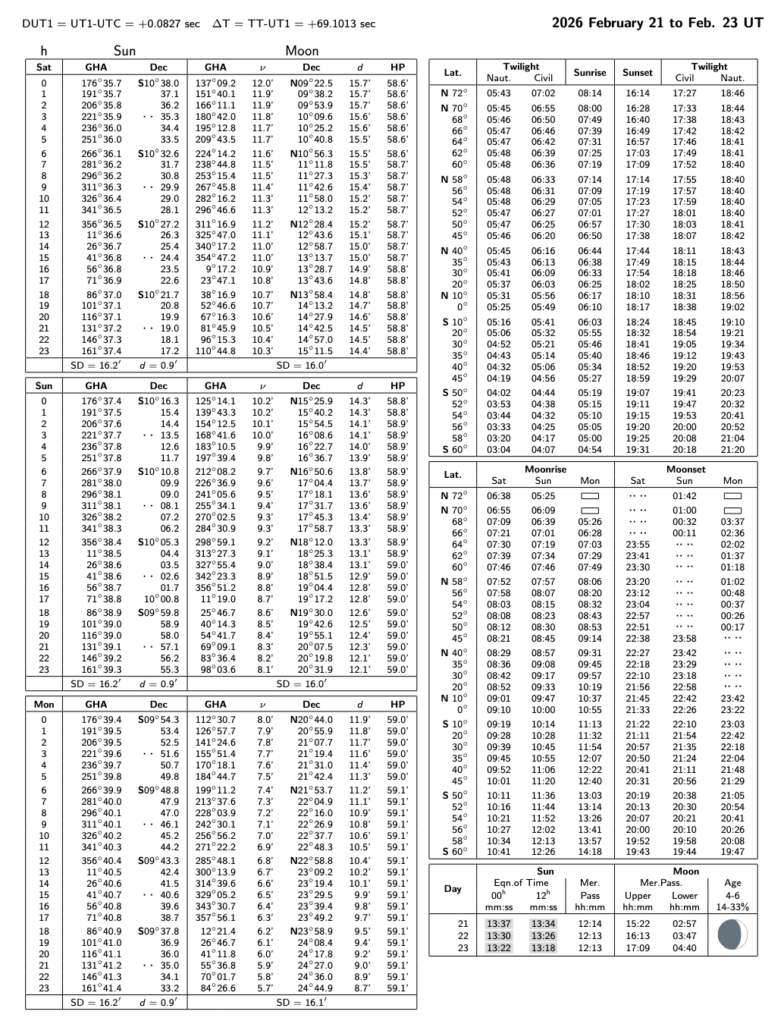
Pages from the Almanac
A two-page extract from the Almanac is shown below, covering the 21st, 22nd and 23rd of February 2026. The first page shows the position of the vernal equinox (Aries) and the positions of the planets Venus, Mars, Jupiter and Saturn. The positions of the planets are listed in the almanac for every hour and day of the year.
The geographical position (GP) of a star is star’s projection onto the surface of Earth. It is the position on the Earth’s surface determined by the line connecting the star to the centre of the Earth. Finding the GP of a star is essential for determining its position.
The almanac also presents the coordinates of the brightest stars in the sky in the celestial sphere coordinate system. The coordinates are given by the day, hour by hour (0 to 23) in Greenwich Mean Time (UTC-0).
Coordinates of celestial bodies
Celestial bodies are positioned in terms of Greenwich hour angle (GHA) and declination (Dec). The Greenwich hour angle is equivalent to longitude, but ranges from 0° to 360° as one moves westwards. It should be noted that longitude, on the other hand, ranges from 180°E to 180°W. This coordinate is used to measure a position on Earth, generally the GP of a celestial body.
The table below shows the correspondence between the two coordinate systems. It is simply a matter of remembering that the Greenwich hour angle continues to increase up to 360°.
Declination is the same as latitude. It ranges from 90°S to 90°N. The only difference is that it is used exclusively for coordinates on the celestial sphere. We therefore use it to describe the position of stars, planets or the Sun.
The position of stars is expressed in terms of the sidereal hour angle (SHA). This is a coordinate specific to stars. Like longitude, it measures a star’s position from east to west. However, the SHA ranges from 0° to 360°.
Below, we can see that on 21 February 2026 at midnight (UTC-0), the GP of Venus is GHA 165° 55.8′, Dec S07° 55.6′. We will see in another text how to interpret these positions. For now, the aim is to familiarise ourselves with the documents.
The following page shows the position of the foot of the Sun and the Moon, as well as the times of sunrise and sunset at the Greenwich meridian. We can deduce from this second page that on 22 February 2026 at 1300 (UTC-0), the GP of the Sun will be at GHA 341° 38.3′, Dec 10° 06.2′.
Without an astronomical almanac, we do not know where the stars are.
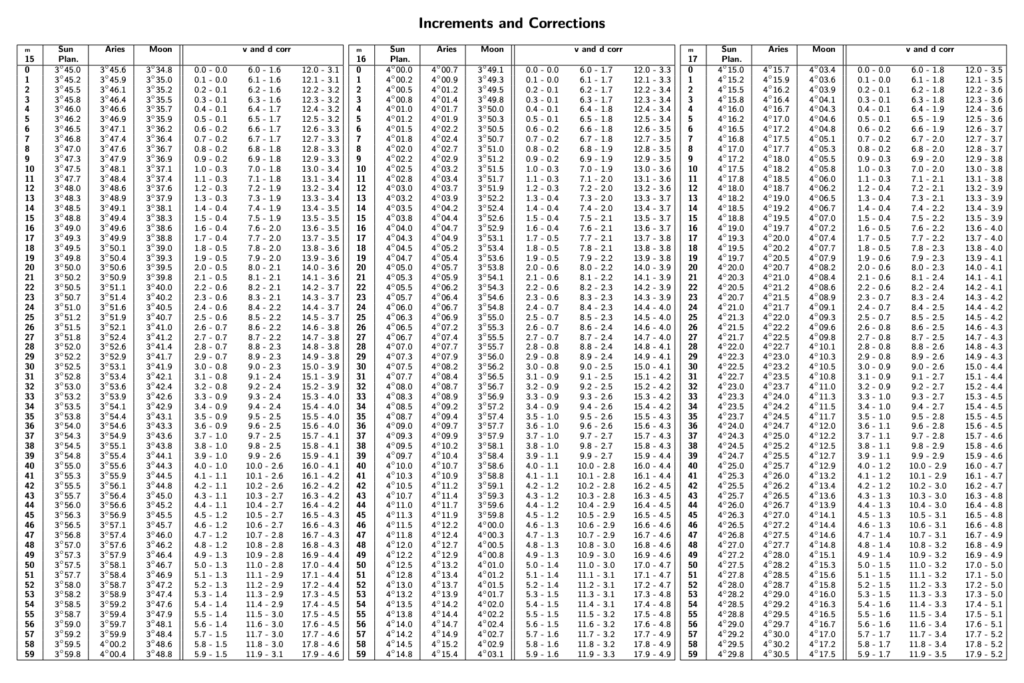
Correction table
An example of a correction page from the Almanac is given below. These pages are fixed and do not vary with the date.
The correction pages are used to interpolate the GP of celestial bodies outside of whole hours. They should be read in the same way as an Excel file. We are only interested in the intersection of a row and a column (and the rest of the table is used for any future calculations).
For example, we can see below that the correction to the GHA of the Sun’s GP, for 15 minutes 23 seconds, is 3° 50.7′. And so on for other hours, seconds, or other celestial bodies in the sky (point of Aries, Moon). These pages will become clearer with use. At this stage, it is important to remember that corrections must be applied to the positions obtained. These corrections can be calculated, in particular, by consulting these tables.
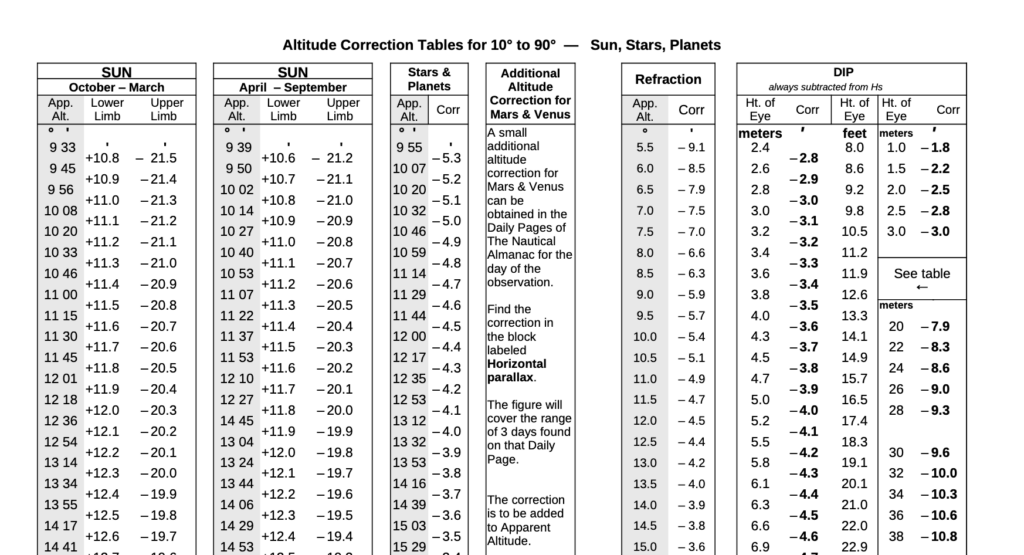
Corrections to sextant readings
Measuring an angle using a sextant requires corrections. For example, the Sun is a relatively large disc in the sky. Depending on whether the angle is measured from the upper limb or the lower limb, the measured angle will differ. Depending on the measurement chosen, a correction must be applied to measure the angle from the centre of the Sun.
Similarly, corrections must be made for low-altitude stars, for refraction, and for the fact that taking a measurement at a sufficiently high altitude above sea level can influence our results (dip). These corrections are incorporated into the calculations and are necessary to establish a reliable position. The tables below are used to make these corrections. We will see how to use them later.
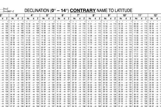
Ho 249 Reduction Table
Volumes 2 and 3
The Ho 249 reduction table is free and comprises three volumes. Volumes 2 and 3 are timeless and are used to solve intermediate calculations. These documents replace the calculator.
In practice, one looks for a page to read the relevant table entry based on the information one has. A full explanation of what these tables mean will be the subject of a separate article.
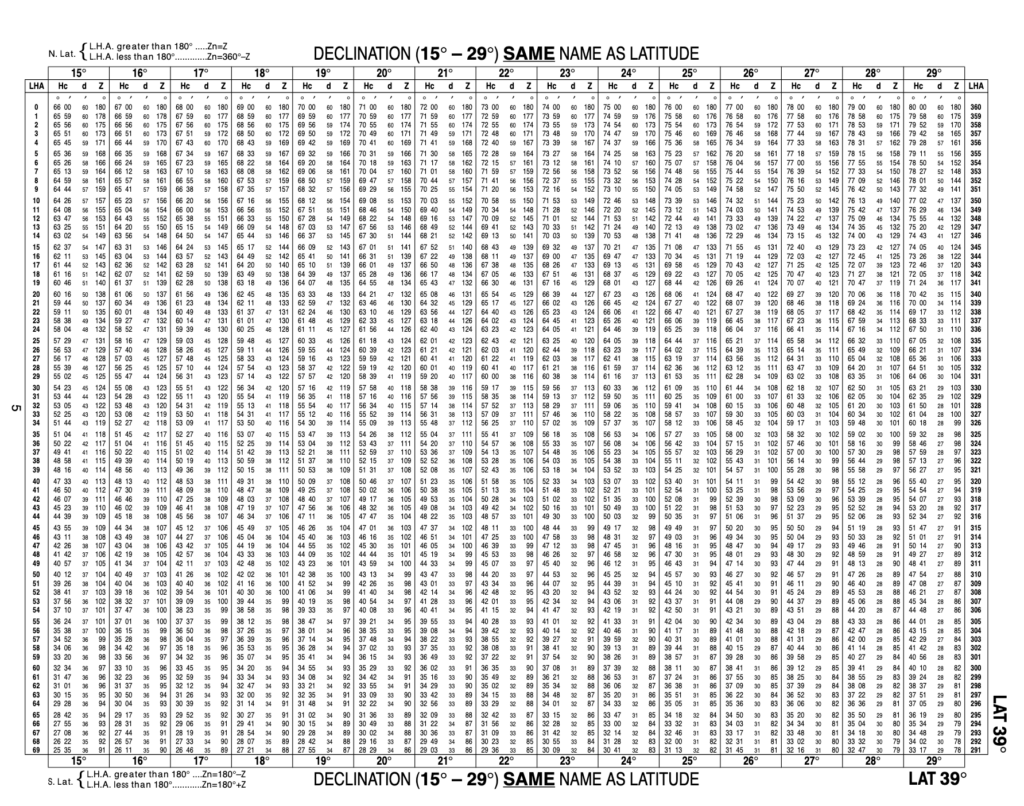
In these modern times, when mobile phones have more computing power than the computers that were on board the Apollo missions, it is difficult to appreciate how a table performing these calculations was of inestimable value in the pre-computer era. Today, these pages can be replaced by two equations and a calculator.
Volume 1
The first volume of Ho 249 gives the direction (Z_n) and the altitude (H_c) of various stars as a function of latitude and longitude. It is an invaluable aid for identifying which stars will be visible in a given part of the world, as well as their approximate position relative to your location on Earth. It is a practical publication for planning sextant observations. This publication changes over time, so it must be kept up to date.
Below is an extract from the table for a latitude of 87°N. It shows the calculated altitude (H_c) and the direction (Z_n) of various visible stars depending on the relative position of the vernal equinox (LHA ♈). For example, if the relative hour angle of the vernal equinox (LHA ♈) is 28°, then the star Pollux will be visible to the east (Z_n = 090°), at a calculated altitude of (H_c) of 27° 59′ above the horizon (if you are at a latitude of 87°N).

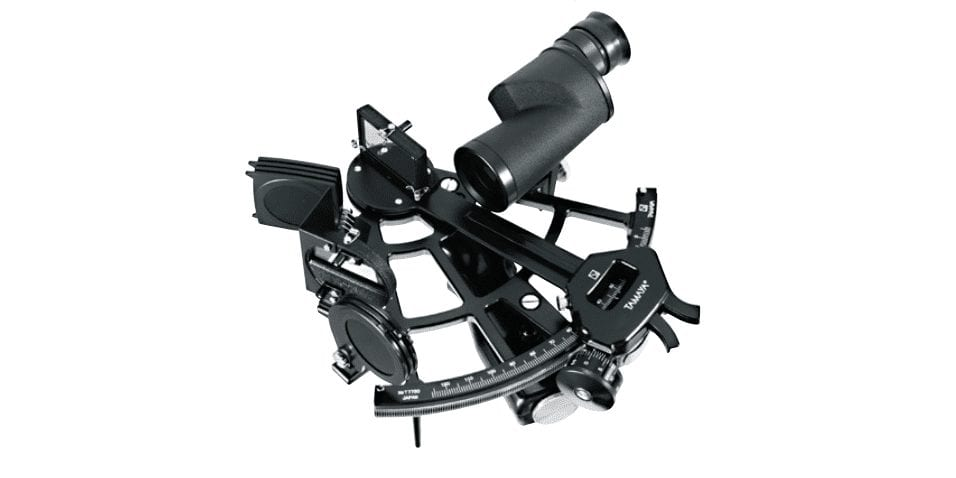
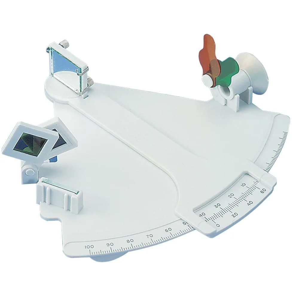
Obtaining a sextant
The price of sextants varies greatly depending on the quality of manufacture. In Canada, Tamaya sextants are the maritime industry standard (made of steel, at $4,500 each). Mark plastic sextants are perfect for taking (and passing!) a course in celestial navigation. They are, of course, of lower quality. In particular, they warp with temperature changes. As a result, the accuracy of the angles measured is lower.
My personal sextant is a Mark 25 (accurate to 0.2′) and it spends more time than not in its storage box. If I need to take astronomical observations at sea, the vessel I’m on usually has professional-grade sextants. When I took my first course in celestial navigation, I chose the highest-quality plastic model because I knew I would have to use it for the practical exam. If you only need to take a classroom course, the cheapest model is probably sufficient.
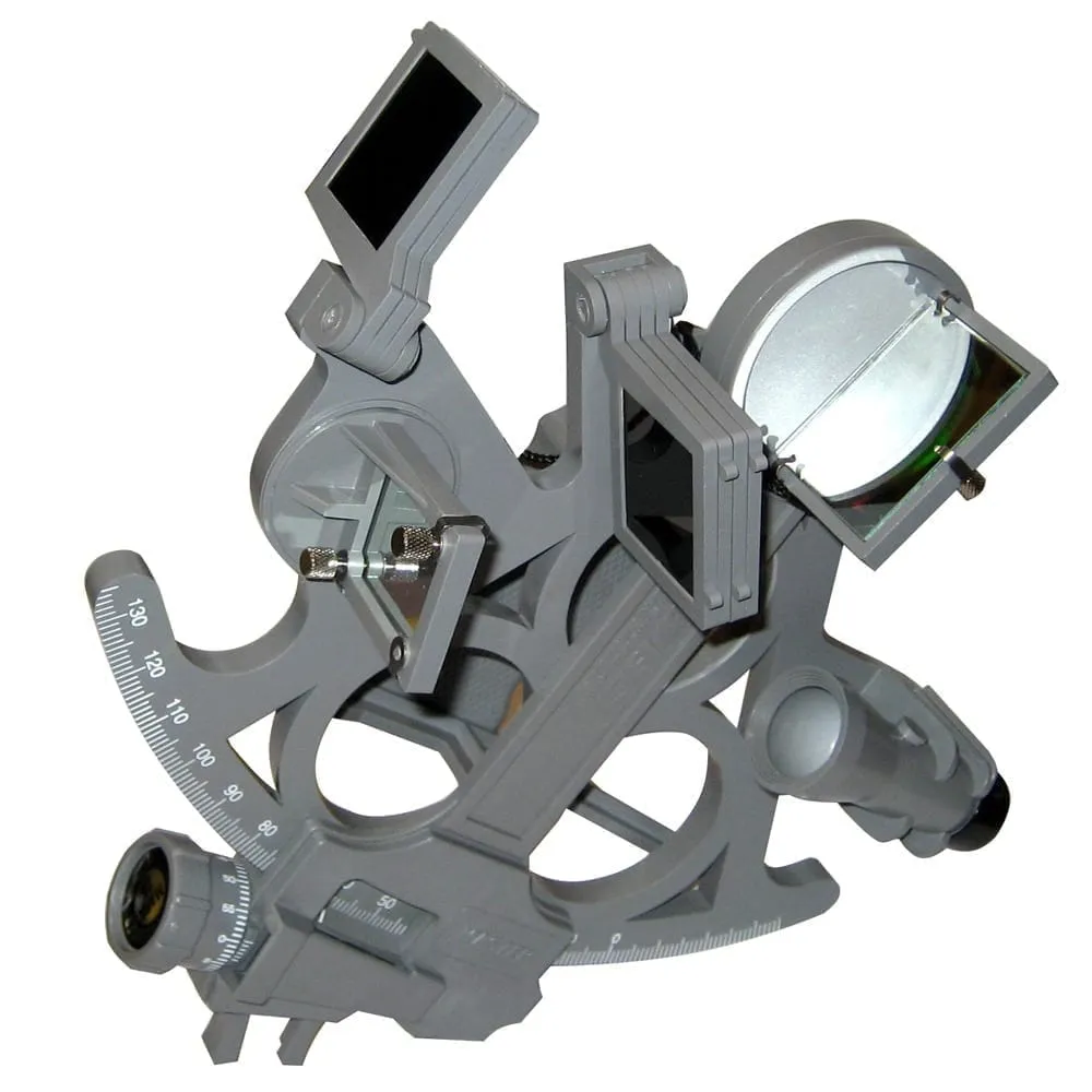
There’s no need to spend more to get started. If you become a professional navigator, chances are your employer will provide you with a sextant.
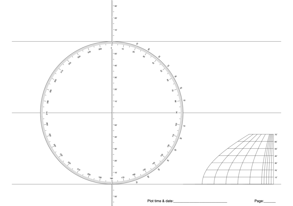
Paper for plotting bearings
The last page of the Nautical Almanac includes paper for plotting bearings for celestial navigation. If space is not an issue, it is best to print these pages in landscape format (11″ x 17″) and allow for the possibility of making mistakes. It is therefore best to use a graphite pencil and have a good supply of printed sheets. If your chart table is small, you may need to use the 8.5″ x 11″ format.
Bear in mind that the latitude is fixed (the scale is graduated), but the longitude still needs to be drawn in. This is because the units of longitude distance vary with latitude. Consequently, you must use the scale shown at the bottom right of the image, depending on the latitude where the drawing will be made.
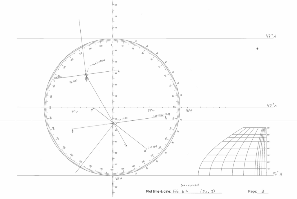
Eventually, you will be able to create your own masterpieces, such as the image below. Note that the latitude is 47°N (near Newfoundland) and that the longitude scale is drawn according to this latitude. You can see that the scale at the bottom right includes an interpolated length at 47°N, allowing for a better approximation of the longitude scale.
A star chart
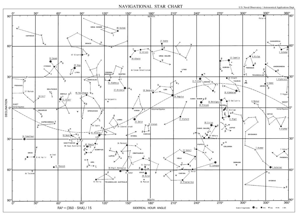
The US Naval Observatory provides a star chart free of charge. I include an introduction to it in a text on the theory of celestial navigation.
Conclusion
This text provides a brief overview of the tools and instruments that will be essential for astronomical navigation. Learning how to use them is the subject of separate texts. It is therefore normal, at this stage, not to know what the Greenwich hour angle is, or even a calculated altitude H_c. These concepts will become clearer as you read the other texts. All you need to remember at this stage is that these documents and tools are necessary for astronomical navigation.
5 Responses
[…] through spherical triangulation. This part is new, covered below, and requires either the use of reduction tables or trigonometric […]
[…] discussed in the article on required publications and equipment, the specialised paper can be found in the final pages of the online Almanac. It is not mandatory […]
[…] twilight is provided for each day in the pages of the Almanac. The time depends on the latitude and is given only in Greenwich Mean Time (UTC-0). You must […]
[…] Astronav: essential tools and documentsThe theory of AstronavigationHow to do and read sextant sightsFinding the GP of a Celestial BodySpherical Triangles and Sight Reduction […]
[…] to identify when the foot of the Sun is at our longitude. We can determine this information from the Almanac and an estimated […]