This text is the last in the series on celestial navigation. It applies the material developed in the previous texts to determine a position from two observations of the sun. In English, this technique is known as a sun-run-sun.
In addition to astronomical navigation techniques, it draws on the concept of transposing a position line ( running fix), which is assumed to be understood in this text. If required, this technique is taught in Level 2 Chart and Navigation courses , or in a Sail Canada Intermediate Coastal Navigation course. Videos explaining the technique can also be found online.
A transposed line
A solar bearing allows you to obtain a running fix. If the course and speed over ground (COG/SOG) are known, you can transpose this fix at the time of a second bearing to obtain a position. Essentially, a sun-run-sun is nothing more than a running fix applied to solar bearings. The advantage is that it can be done in broad daylight using a single celestial body (the sun). The drawback is that it requires the course and speed over ground.
Essentially, the application of the technique boils down to the following procedure:
- Using an estimated position, take a sextant reading of the sun and derive a position line;
- Project our estimated position onto this position line.
- Sail for three to four hours with a known course and ground speed. Deduce a second estimated position;
- Take a second sight of the sun and obtain a position line.
- Transpose the first line of position to the time of the second to obtain your position.
The only new aspect of this procedure is projecting our estimated position onto this position line. We know that we are on the position line at the time of the observation. Finding the projection involves finding the position closest to the estimated position that lies on this line. It is simply the intersection of the position line and the azimuth of the sun. From this new position, we estimate the new position by applying the course and speed over ground.
Example
On 17 July 2025 at 1000 (UTC-5), your vessel is at the estimated position 47° 28’N / 064° 03’W. You take an initial reading of the lower limb of the sun and obtain a sextant altitude of 58° 40.2′. You then sail with a course/speed of 090°/6 knots. At 14:17 (UTC-5), you take a second reading of the sun and obtain a sextant altitude of 45° 33.5′ (lower limb). Given that the combined correction for your sextant for elevation and index is -2.7′, determine your position at 14:17 (UTC-5).
Solution
At 1000 UTC-5, it is 1500 UTC-0. From the Almanac (p. 133), we can deduce the position of the sun, which is GHA 43° 26.9′ / Dec 21° 07.2′. As the time is a whole hour, no correction is required for the minutes and seconds.
Our estimated position is further west than the sun’s GHA; consequently, our local hour angle (LHA) is the difference between the sun’s GHA and our position, plus 360°. Thus, our LHA is 339° 23.9′. Using spherical trigonometry equations, we obtain H_c = 58° 50.9′ and Z= 140° 37.0′.
Note that our latitude is north and that the LHA is greater than 180°. Consequently, Z_n = Z= 140° 37.0′.
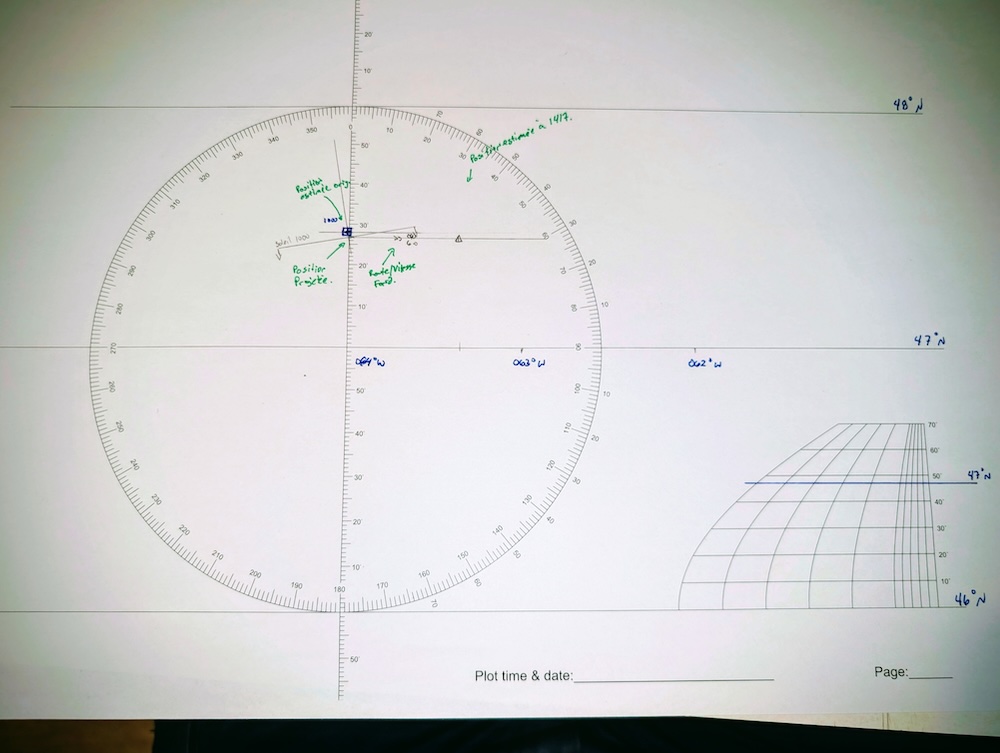
The observed altitude is obtained by subtracting the combined error from the sextant altitude, i.e. 58° 37.5′. From the Almanac’s correction tables, we note a correction of 15.4′ for the lower part of the sun (as it is July). The observed altitude is therefore 58° 52.9′. The deviation from the estimated position is thus 1.4 nautical miles in the direction of the GP of the sun (140°). This information allows us to plot the first line of position. We can thus project our estimated position onto this line at 1000, which is 47° 26.9′ N / 064° 01.7W.
Our course over ground is 90° (east) at a speed of 6 knots. As we sail for 4 hours and 17 minutes, our new estimated position will be 25.7 nautical miles east of our projected position.
The plot is shown below, with some annotations in green (which are included for educational purposes only). We find a new estimated position of 47° 26.9′ N / 063° 23.7′ W. Note that this new position is no longer at the same latitude as the original estimated position because of the projection.
At 14:17 UTC-5, it is 19:17 UTC-0. At 19:00, the Almanac tells us that the sun’s position is GHA 103° 26.7′ / Dec 21° 05.4′. A correction of 17 minutes, or 4° 15.0′, must be applied to the GHA. Similarly, the correction for declination is -0.1′ (by interpolation). Thus, the GP of the sun is at GHA 107° 41.7′ / Dec 21° 05.3′.
At this time, the Greenwich Hourly Angle (GHA) is greater than our estimated longitude, so the Local Hourly Angle (LHA) is the difference between the two, i.e. 44° 18.0′. This information is sufficient to find H_c = 45° 46.6′ and Z= = 110° 52.9′. As the local hour angle is less than 180° and our latitude is north, we obtain Z_n=360° - Z = 249° 7.1′.
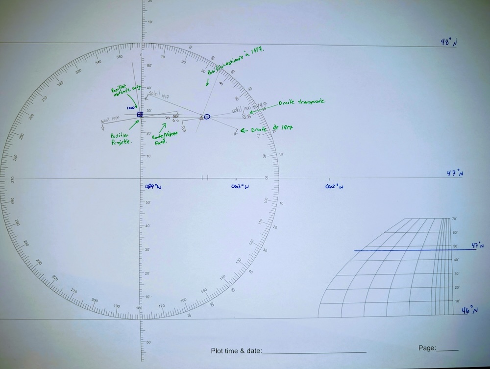
Our sextant reading is 45° 33.5′, so the apparent altitude is 45° 30.8′. Consulting the correction table, we obtain a value of 15.1′ for the lower part of the sun (in July). Thus, the observed altitude is 45° 45.9′. The position error is therefore 1.7 nautical miles and must be applied in the direction opposite to the GP of the sun (069°). With this information, we can plot a second line of position.
The complete plot is shown in the image below. The green annotations reflect the steps detailed in the paragraph (and are included solely for educational purposes). The final position is circled in blue (in pen) to improve visibility on screen. The position obtained is 47° 26’N / 063° 18′ W.
Conclusion
If you are sailing long distances during the day, the sun-run-sun method is very useful. All you need is a single celestial body and a little patience. It can be applied at any time of day, provided you allow sufficient time to elapse between the two observations (otherwise, the uncertainty in the position increases).
The technique also illustrates that transposing astronomical position lines is fundamentally the same idea as transposing an ordinary position line. This is only the first time the technique has been applied, but it can also be applied to star sightings. In particular, if the time elapsed between observations results in a distance of more than one nautical mile, we should correct our observations by transposing the lines to improve accuracy.
This text is the last in the series on astronomical navigation. This series of texts does not cover all techniques, but it does cover the most important ones. The examples given in the texts deal with the Gulf of St Lawrence, the Caribbean, the Mediterranean Sea and Atlantic crossings.
In terms of additional exercises, it may be worthwhile to practise position fixes in the Southern Hemisphere, east of the Greenwich Meridian, in the Pacific, or by taking observations of the planets Mars and Venus. Each of these cases involves slight differences in calculation that must be incorporated into the technique to determine a position.
Did you enjoy this article? You can read more in the Learn section.


1 Response
[…] to plan your star sightsApplication: performing a noon sightApplication: a complete star sightApplication: the sun-run-sun techniqueApplication: finding the compass […]