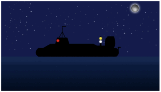
Becoming a Coastal Navigation Instructor
Here is the fastest way for a Quebecer to become a Sail Canada instructor: get certified in another province!
This is the third text on how to build a navigation plan. It uses a boat delivery from the Bahamas to Canada to flesh out a real example. Read it to understand how.
This is the second of three texts on how to build a navigation plan. It uses a real passage plan from the Bahamas to Canada. Read it to understand how to plan a passage.
This first text of three shows a recipe to build a passage plan. Read it to understand and master the process of planning a safe navigation.
Read this if you wish to understand how onboard computers find time minimizing routes.
Tired of the graphical addition of vectors? Learn algebra and remember those trigonometric identities thaught by your high-school teacher
This software is for instructors and professors of navigation. It draws navigation vectors as per the International Maritime Organization drawing convention.
It is not a conspiracy, nor a computer bug. It is a fact established mathematical fact in 1837: every rectangular map of the world is a lie.
Tides are special. Almost all aspects of the weather are the outcome of complex interactions: cloud formation, winds, or rain patterns. For any of these dimensions, advanced numerical modeling is required in order to produce reliable forecasts, often limited to a window of four days. These models rely on large...
Is the rule of sixths better than the Oceans and Fisheries “rule of twenthieths” for manually calculating tides? Here is the punchline: they both yield similar results.