
This article is the ninth in a series on celestial navigation. It explains how to take a noon sight. Before reading this, you should have a good grasp of the first six theoretical articles.
To take a noon sight, you need to:
- Have a rough idea of the sun’s maximum altitude based on an estimated position.
- Identify the sun’s maximum altitude using the sextant (and note the time).
- Perform a few calculations to determine your position.
The noon sight is the astronomical navigation technique that requires the least amount of calculation. This is what makes it attractive. On the other hand, you must wait until it is exactly local noon, meaning this technique can only be used once a day. For an ocean crossing, this is more than sufficient. For situations requiring greater flexibility, you must use techniques that work at any time of day. In particular, if clouds prevent you from seeing the sun, you must resort to another technique.
Approximate time of maximum altitude
The maximum altitude of the sun is the height, measured with a sextant, at which the sun is highest in the sky. In the case of the sun, this maximum altitude occurs when the base of the sun is at our longitude. It is this important property that makes the calculations simple. When the sun is at our longitude, we say it is local noon. As a general rule, local noon is not when our watch shows midday!
To find out when local noon occurs, we need to identify when the foot of the Sun is at our longitude. We can determine this information from the Almanac and an estimated position.
To determine the time of local noon, we must first identify the time of the passage through the Greenwich meridian (noted as ‘mer pass’ in the almanac). This time will be in UTC-0. Next, we must correct this time for our longitude at a rate of 15° per hour. Finally, we must convert this time to local time, depending on the time zone.
As the position is estimated, local noon is also estimated. Consequently, we should add a 30-minute window before the estimated time to begin taking our observations.
Example
Suppose our estimated position is 47° 43′ N / 063° 01′ W (somewhere in the Gulf of St Lawrence). What time will local noon be on 1 July 2026 if we use Quebec’s summer time zone (UTC-5)?
Solution
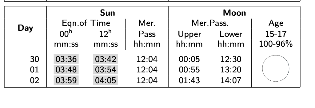
Page 123 of the Almanac allows us to identify the time of the sun’s passage through the Greenwich meridian (Mer. Pass.). On 1 July, the time is 12:04 UTC-0.
As we are at position 063° 01′ W (or 63.017°), we must add 4.2011 (63.017 / 15) hours to the identified time, i.e. 4 hours, 12 minutes. Thus, the sun will be at our estimated longitude at 16:16 UTC-0. To convert this time to Quebec daylight saving time, we must subtract five hours to obtain 11:16 UTC-5. Thus, local noon is at approximately 11:16. It is best to begin taking sextant readings at around 10:45, to ensure we do not miss the maximum altitude.
Identifying the maximum altitude
Before the scheduled time window, you need to find the ideal combination of filters to use on your sextant. Remember to protect your eyes! You can find a suitable combination by carrying out a few tests. You also need to choose which part of the Sun you will use for your observation. Personally, I always work with thelower limb.
At the start of the identified time window, you must begin taking sextant readings. You must simultaneously note the identified altitude and the time (accurate to the second!). It is useful to create a table (see below) which you fill in as you go along. Start with readings every five minutes. Then, as time goes on, increase the frequency of the readings (to every minute).
| Time (local time) | Measured altitude (° ‘) |
| Time 1 | Reading 1 |
| Time 2 | Reading 2 |
| etc. | etc. |
Taking several readings is useful for checking that no measurement errors have been made, but also for identifying the trend. Even when you think you have identified the maximum height, it is useful to take a few additional readings to be certain you have the correct measurement. As a guide:
- Before reaching the maximum height, the sun’s altitude will increase. The closer you get to the maximum height, the less pronounced the increases will be.
- At the maximum height, the sun’s altitude will no longer increase.
- After the maximum height, the sun’s altitude will decrease. The more time passes, the faster the sun will descend.
When you are close to the maximum altitude, it is easy to think that the sun is at its maximum altitude because the changes in altitude are smaller. It is best to be patient and take a few additional readings to ensure that this is indeed the correct time.
Finally, note the general direction you are facing when taking your sextant reading. Are you facing north or south? In Canada, you always face south when observing the sun, but this is not always the case in other parts of the world. This information already gives us a rough idea of where we are sailing.
Calculations specific to position identification
Determining longitude is very simple: take the time at which the observation was made, convert it to UTC-0, then subtract the time of passage over the Greenwich meridian. We then convert this time difference at a rate of 15 degrees per hour to obtain the longitude.
To determine the latitude, you must first apply the appropriate altitude corrections to the Sun’s altitude to obtain the observed altitude. Next, you must look up the Sun’s declination in the Almanac (at the time of the observation).
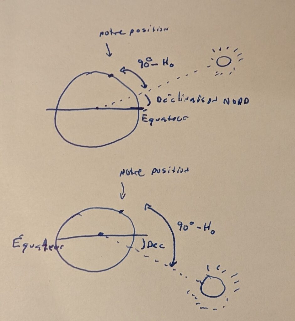
In the text on the theory of celestial navigation, we saw that the distance 90° - H_o corresponds to a distance at the foot of the celestial body (simply multiply this angle by 60 to obtain the distance in nautical miles). In the specific case where the celestial body is at local noon, this distance corresponds exactly to the difference in latitude. We can therefore use this information to calculate it:
- If we are at an estimated position in the Northern Hemisphere and the Sun’s declination is north (it is summer), then our latitude corresponds to the sum of 90° - H_o and the declination. This is our distance from the Sun plus the Sun’s distance from the equator.
- If we are at an estimated position in the North and the Sun’s declination is south (it is winter), then we must subtract the Sun’s declination from 90° - H_o. The Sun is ‘lower’ than the equator. We must therefore subtract its declination to obtain the difference between our position and the equator (i.e. the latitude).
- If we are at an estimated position in the Southern Hemisphere and the Sun’s declination is north, we must then subtract the Sun’s declination from 90° - H_o.
- If we are at an estimated position in the Southern Hemisphere and the Sun’s declination is South, we must then add the Sun’s declination to 90° - H_o.
The first two cases are illustrated in the image below. The estimated position is in the Northern Hemisphere. We can clearly see under which circumstances we must add or subtract the declination. (Personally, I have to draw the diagrams to remember this!) In the top diagram, the Sun’s declination is north. As the measurement 90° - H_o gives us the difference in latitude from the Sun, we must add the declination to obtain our latitude. In the diagram below, the declination is to the south. As the measurement 90° - H_o gives us the difference in latitude relative to the Sun, we must subtract the declination to obtain the latitude.
And… that’s it! With these calculations, we have our longitude and latitude.
Exercises
Exercise 1
On 1 July 2026, you obtain the maximum sun elevation of 65° 19.2′ at 11:18 UTC-5 (lower limb). Your eye height is 2.0 metres and your sextant’s index error is 0.1′. What is your position?
Solution
If it is 11:18 UTC-5, this means it is 16:18 UTC-0. The difference from the time the Sun crosses the Greenwich meridian is four hours and fourteen minutes, or 4.2333 hours. At a rate of 15 degrees per hour, this corresponds to 63.5°, or 63° 30′ W.
At 16:00 UTC-0, the sun’s declination is 23° 04.4′ N. The correction specific to the 18 minutes must be added, which can be done by interpolation. Between 16:00 and 17:00, the change in the Sun’s declination is -0.2′. For 18 minutes, we must take 30% (18 / 60) of this change, i.e. -0.1 (rounded). The Sun’s declination is therefore 23° 04.3′ N at 16:18 (UTC-0).
Taking into account a sextant altitude of 65° 19.2′, an index correction of 0.1′ and an elevation correction of -2.5′, the apparent altitude is 65° 16.6′. Given that it is July, the correction to the apparent altitude for the lower part of the sun is 15.5′. Thus, the observed altitude is 65° 32.1′. Consequently, the distance to the foot of the sun is 24° 27.9′ (90° – 65° 32.1′). (This is irrelevant for determining our latitude, but it corresponds to 1467.9 nautical miles.)
The declination is north and our estimated position is north. Consequently, we must add the declination to obtain our latitude, which is 47° 32.2′ N.
Thus, our position is 47° 32.2′ N / 63° 30′ W.
Exercise 2
You are at an estimated position of 35° 10′ N / 018° 42′ E. On 1 July 2026, you obtain the maximum sun altitude at 13:49, Athens Summer Time (UTC 3). The altitude of your reading is 77° 36.8′, the index error of your sextant is -0.3′ and your reading was taken 2 metres above sea level. What is your position?
Solution
Note that you are somewhere in the Mediterranean Sea. The only subtlety of this calculation is that your position is east of the Greenwich meridian.
At 13:49 UTC+3, it is 10:49 UTC-0. The difference from the time of crossing the Greenwich meridian is -1h15, or -1.25 hours. At a rate of 15 degrees per hour, this gives -18.75°, or a longitude of 18° 45′ E.
At 10:00 UTC-0, the sun’s declination is 23° 05.4′ N. We must add the correction specific to the 49 minutes, which can be done by interpolation. Between 10:00 and 11:00, the change in the Sun’s declination is -0.1′. For 49 minutes, we must take 30% (49 / 60) of this change, i.e. -0.1 (rounded). The Sun’s declination is therefore 23° 05.3′ N at 10:49 (UTC-0).
For a sextant altitude of 77° 36.8′, an index error of -0.3 and an elevation correction of -2.5′, the apparent altitude is 77° 34.6′. Given that it is July, the correction for the lower part of the sun is 15.7′. Consequently, the observed altitude of the sun is 77° 50.3′. Incidentally, the distance at the foot of the sun is 12° 09.7′. Given that we are in the North and that the declination is north, we must add the declination. This gives us a latitude of 35° 15.1′ N.
Thus, our position is 35° 15.1′ N / 18° 45′ E.
Exercise 3
You are at the approximate position 28° 14.0′ S / 100° 08.4′ E on 15 December 2026. The ship’s time is in the Jakarta time zone (UTC +7). Determine the local time to start taking your observations for a noon fix.
Solution
The time of the sun’s passage over the Greenwich meridian on 15 December 2026 is 1155. Given that we are at 100° 08.4 E, we must subtract 6.676 hours, or 6 hours 41 minutes. The estimated time of the noon point is therefore 05:14 (UTC-0). To convert to local time, add 7 hours, giving 12:14 (UTC 7). To start the observation window, subtract 30 minutes to obtain 11:44 (UTC 7).
The time slot for taking the readings is therefore 11:44 (UTC-7).
Exercise 4
On 5 November 2026, you are at the estimated position 16° 56’N / 037° 39’W (during your Atlantic crossing). The ship’s time is in the UTC-3 time zone. At 11:15 local time, you observe the maximum altitude of the Sun at 57° 13.4′ (lower limb). Your index error is -0.5′ and your eye level is 5 m above sea level. What is your position?
Solution
On this date, the time the sun crosses the Greenwich meridian is 11:44 (UTC-0). Your observation time is 14:15 (UTC-0). The difference is therefore 2 hours 31 minutes, or 2.517 hours. At a rate of 15 degrees per hour, your longitude is thus 37.75°, or 37° 45′ W.
On 5 November 2026, the Sun’s declination is 15° 47.4’S at 14:00. The correction for the additional 15 minutes must be added. Between 14:00 and 15:00, the variation in declination is 0.8′. You must take a quarter of this variation, i.e. 0.2′. The Sun’s declination at 14:15 is therefore 15° 47.6’S.
The sextant height is 57° 13.4′, the index correction is 0.5′ and the correction is 4.0′ (in a borderline case, one could also have taken 3.9′). Consequently, the apparent altitude is 57° 17.9′. In November, the correction for the Sun is 15.6′. Thus, the observed altitude is 57° 33.5′. Therefore, your distance from the foot of the Sun is 32° 26.5′ (or 1946.5 nautical miles).
Your estimated position is north and the declination is south. Consequently, you must subtract the declination from the distance to the foot of the sun to obtain the latitude. This gives 16° 39.1’N.
Thus, our position is 16° 39.1’N / 37° 45′ W.
Conclusion
Taking a noon position is a special case of celestial navigation that requires very little calculation. You need the correct time, the Sun’s declination and a reading of the maximum altitude taken with a sextant. The method requires so little calculation that some almanacs provide a summary page containing only the Sun’s declination for each day of the year. These summary pages are, of course, less accurate than a full almanac, but can be used in an emergency.
The execution of a noon fix depends on the visibility of the sun at local noon. If the sun is hidden by clouds, its position cannot be determined using this technique. More general techniques must be used to take readings at any time.
Did you enjoy this text? You can read others in the astronomical navigation series, or refer to other texts in the Learn section.


1 Response
[…] to plan your star sightsApplication: performing a noon sightApplication: a complete star sightApplication: the sun-run-sun techniqueApplication: finding the […]