Here is a series of five reduction exercises based on sextant observations, using spherical trigonometry. To understand how to complete these exercises, you will need to have read the text on reducing sextant observations or, more generally, the series of texts on celestial navigation.
Exercise 1
Your estimated position is at 50° 18.7’N / 058° 23.89’W at 1825 UTC-3.5. The observed altitude H_o of the star Pollux is 33° 22.6’. The star’s GP is GHA 348° 05.1′ / Dec 27° 57.1 N. Identify H_c, Z, Z_n the distance to the estimated position, as well as the direction in which the actual position lies.
Solution
The RHA is 289° 41.2′. Using the information given in the problem, we can calculate H_c:
\begin{align*}
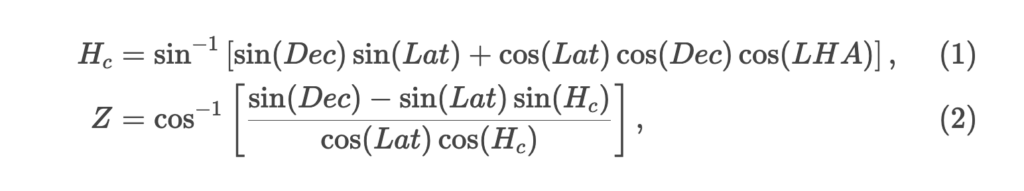
H_c&=\sin^{-1}\left[\sin(27° 57.1 )\sin(50° 18.7’) \cos(50° 18.7’)\cos(27° 57.1)\cos(289° 41.2')\right]\\
&\approx 33° 25.6’.
\end{align*}If we were at the estimated position, we would have taken a sextant bearing of Pollux at 33° 22.6′. As our observed bearing is higher, we can already deduce that our actual position is closer to the GP of the star than the estimated position. Similarly, the distance is 3.0 nautical miles. We can now calculate Z:
\begin{align*}
Z &=\cos^{-1}\left[\frac{ \sin(27° 57.1) - \sin(50° 18.7’)\sin(33° 25.6’.)}{\cos(50° 18.7’)\cos(33° 25.6’)}\right],\\
&\approx 85° 09.5’.
\end{align*}
Note that the LHA is greater than 180° and that the estimated latitude is north. Consequently Z_n = Z = 85° 09.5’.
In summary, we are on a position line that is 3.0 nautical miles from our estimated position. These 3.0 nautical miles are in the direction approaching the GP of the star (in the direction of 85° 09.5’). The position line is perpendicular to the direction 85° 09.5’.
Exercise 2
At 1200 UTC-3.5, you obtain an observed altitude H_o of the Sun of 26° 45.5’. Your estimated position is 47° 25’N / 60° 40’W and the GP of the Sun is GHA 41° 35.6’ / Dec 13° 32.8’S. Identify H_c, Z, Z_n the distance to the estimated position, as well as the direction in which the actual position lies.
Solution
The LHA is 340° 55.8’. Using the information given in the problem, we can calculate H_c:
\begin{align*}
H_c&=\sin^{-1}\left[\sin(-13° 32.8’)\sin(47° 25’) \cos(47° 25’)\cos(-13° 32.8’)\cos(340° 55.8’)\right]\\
&\approx 26° 41.6'.
\end{align*}
If we were at the estimated position, we would have taken a sextant bearing of the sun at 26° 41.6’. As our observed bearing is higher, we can already deduce that our actual position is closer to the GP of the celestial body than the estimated position. The distance is 3.9 nautical miles. We can now calculate Z:
\begin{align*}
Z &=\cos^{-1}\left[\frac{ \sin( 13° 32.8’) - \sin(47° 25’)\sin(26° 41.6')}{\cos(47° 25’)\cos(26° 41.6')}\right],\\
&\approx 159° 10.2'
\end{align*}
Note that the LHA is greater than 180° and that the estimated latitude is north. Consequently Z_n = Z = 159°.
In summary, we are on a position line that is 3.9 nautical miles from our estimated position. These 3.9 nautical miles are in the direction approaching the GP of the star (in the direction of 159°). The position line is perpendicular to the 159° direction.
Exercise 3
At 1532 UTC-3.5, you obtain an observed altitude H_o of the Sun of 19° 12.0’. Your estimated position is 46° 45.5’N / 059° 57.8’W and the foot of the Sun is GHA 101° 28.1’ / Dec 13° 29.9’S. Identify H_c, Z, Z_n the distance to the estimated position, as well as the direction in which the actual position lies.
Solution
The LHA is 41° 30.3’. The only caveat here is that the declination is south. This information must be included in the formula by entering a negative number. Using the information from the problem, we can calculate H_c:
\begin{align*}
H_c&=\sin^{-1}\left[\sin(-13° 29.9')\sin(46° 45.5’) \cos(46° 45.5’)\cos(-13° 29.9')\cos(41° 30.3’)\right]\\
&\approx 19° 12.0'.
\end{align*}
If we were at the estimated position, we would have taken a sextant bearing of the Sun at 19° 12.0’. As our bearing is identical, the position line passes through the estimated position (zero distance). We can now calculate Z:
\begin{align*}
Z &=\cos^{-1}\left[\frac{ \sin(-13° 29.9') - \sin(47° 25’)\sin(19° 12.0')}{\cos(47° 25’)\cos(19° 12.0')}\right],\\
&\approx 136° 58'
\end{align*}
Note that the LHA is less than 180° and that the estimated latitude is north. Consequently, Z_n = 360 - Z = 223°.
In summary, we are on a position line that passes through our estimated position. The position line is perpendicular to the 223° direction.
Exercise 4
Your estimated position is at 50° 18.7’N / 058° 23.89’W at 1825 UTC-3.5. The observed height H_o of the star Rigel is 25° 24.6’. The star’s right ascension is RA 027° 05.1’ / Dec 8° 10.4’S. Identify H_c, Z, Z_n the distance to the estimated position, as well as the direction in which the actual position lies.
Solution
The RHA is 328° 41.2’. The declination is south. This information must be included in the formula by entering a negative declination. Using the information from the problem, we can calculate H_c:
\begin{align*}
H_c&=\sin^{-1}\left[\sin(-8° 10.4')\sin(50° 18.7’) \cos(50° 18.7’)\cos(-8° 10.4')\cos(328° 41.2’)\right]\\
&\approx 25° 30.5’.
\end{align*}
If we were at the estimated position, we would have taken a sextant bearing of Rigel at 25° 30.5’. As our bearing is smaller, the position line moves away from the estimated position. The distance is 5.9 nautical miles. We can now calculate Z:
\begin{align*}
Z &=\cos^{-1}\left[\frac{ \sin(-8° 10.4') - \sin(50° 18.7’)\sin(25° 30.5’)}{\cos(50° 18.7’)\cos(25° 30.5’)}\right],\\
&\approx 145° 15'
\end{align*}
Note that the LHA is greater than 180° and that the estimated latitude is north. Consequently Z_n = Z = 145° 15'.
In summary, we are on a position line that is 5.9 nautical miles away from our estimated position. This distance is away from the GP of Rigel. The position line is perpendicular to the 145° bearing.
Exercise 5
Your estimated position is at 50° 18.7’N / 058° 23.89’W at 1825 UTC-3.5. The observed altitude H_o of the star Hamal is 60° 27.4’. The star’s GP is at GHA 074° 41.0’ / Dec 23° 35.2’N. Identify H_c, Z, Z_n the distance to the estimated position, as well as the direction in which the actual position lies.
Solution
The LHA is 16° 17.1’. Using the information given in the problem, we can calculate H_c:
\begin{align*}
H_c&=\sin^{-1}\left[\sin(23° 35.2')\sin(50° 18.7’) \cos(50° 18.7’)\cos(23° 35.2')\cos(16° 17.1’)\right]\\
&\approx 60° 25.4’.
\end{align*}
If we were at the estimated position, we would have taken a sextant bearing of 60° 25.4’ from Hamal. As our bearing is greater, the position line approaches the GP of Hamal. The distance is 2.0 nautical miles. We can now calculate Z:
\begin{align*}
Z &=\cos^{-1}\left[\frac{ \sin(23° 35.2') - \sin(50° 18.7’)\sin(60° 25.4’)}{\cos(50° 18.7’)\cos(60° 25.4’)}\right],\\
&\approx 148° 37.5’.
\end{align*}
Note that the LHA is less than 180° and that the estimated latitude is north. Consequently, Z_n = 360° - Z = 211° 22.5’.
In summary, we are on a position line that is 2.0 nautical miles from our estimated position. This distance is in the direction of the GP of Hamal. The position line is perpendicular to the 211° bearing.