This text is the tenth in the series on celestial navigation. It covers how to convert three star sightings into three position lines, enabling you to determine your position. All the knowledge required to carry out this work has already been covered in the other texts. The challenge of this exercise lies in integrating all the parts covered. The exercise is by no means theoretical: it is precisely this technique that is used to determine one’s position.
In terms of difficulty, the exercise above is slightly easier than in practice: the coordinates of the estimated position are integers, the measurement errors are not very large (i.e. the estimated position is excellent) and the measurements are all taken within the same minute.
Exercise
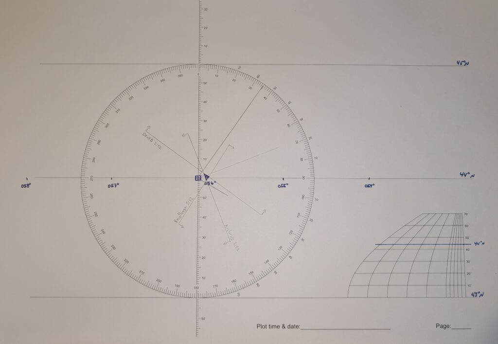
On 10 June 2026, you are at the estimated position 44°N / 056°W. Your sextant has an index error of -0.4′ and your eyes are 3.0 m above water level. At 21:52 (UTC-3.5), you take the following bearings:
- Star Deneb: 31° 42.8′;
- Star Rasalhague: 43° 34.8′;
- Star Arcturus: 63° 42.4′.
Determine your position.
Solution
From sextant altitude to observed altitude
The table below summarises the corrections to be applied to the identified readings. Remember that you must first apply the observer-related corrections, namely the index correction and the elevation correction. Because the index correction is positive, the correction is negative. Furthermore, the elevation correction is always negative. The latter is -3.0′, and is obtained from the correction table in the Almanac.
The star-specific corrections are also obtained from the correction table in the Almanac. These corrections are specific to the apparent altitude of each observation.
| Deneb | Rasalhague | Arcturus | |
| H_s | 31° 42.8′ | 43° 34.8′ | 63° 42.4′. |
| Index | 0.4′ | 0.4′ | 0.4′ |
| Elevation | -3.0′ | -3.0′ | -3.0′ |
| H_a | 31° 40.2′ | 43° 32.2′ | 63° 38.8′ |
| Star correction | -1.6′ | -1.0′ | -0.5′ |
| H_o | 31° 38.6′ | 43° 31.2′ | 63° 39.3′ |
For the rest of the calculation, we must work with the observed altitude.
Reduction of observations
At 21:52 UTC-3.5, it is 01:22 UTC-0 on 11 June 2026. The vernal point has a GHA of 274° 23.6′ at 01:00 and a correction of 5° 30.9′ must be added for the 22 minutes. The GHA at 0122 is therefore 279° 54.5′. The table below summarises the information required to reduce the observations (taken from the Almanac, p. 108).
Once the GHA has been obtained, the sidereal hour angle (SHA) of each star is added to obtain the GHA for each star. The sidereal hour angles are taken from the Almanac. If the result exceeds 360°, 360° must be subtracted to obtain the GHA.
Next, the local hour angle (LHA) is required. Here, the estimated longitude is west, so the longitude must be subtracted from the star’s GHA. If the result is less than 0, 360° must be added to obtain the LHA.
With the LHA, the estimated latitude and the star’s declination, we have everything we need to perform the reduction. Below, I use spherical trigonometry equations to obtain the calculated altitude (H_c) and the azimuth of the star (Z_n). The conversion recipe from Z to Z_n is the same for the first two stars, but differs for the third.
| Deneb | Rasalhague | Arcturus | |
| Vernal GHA | 279° 54.5′ | 279° 54.5′ | 279° 54.5′ |
| SHA star | 49° 24.7′ | 95° 57.1′ | 145° 46.6′ |
| GHA star | 329° 19.2′ | 015° 51.6′ | 065° 41.1′ |
| Estimated longitude | 056° 0.0’W | 056° 0.0’W | 056° 0.0’W |
| LHA star | 273° 19.2′ | 319° 51.6′ | 009° 41.1′ |
| LHA > 180°? | Yes. | Yes. | No. |
| Declination | 45° 22.3′ N | 12° 32.4′ N | 19° 02.7’N |
| Estimated latitude | 44° 0.0’N | 44° 0.0’N | 44° 0.0’N |
| Same name? | Yes. | No. | Yes. |
| H_c | 31° 34.6′ | 43° 26.5′ | 63° 43.4′ |
| Z | 55° 24.4′ | 119° 55.4′ | 158° 38.3′ |
| Z_n | 55° 24.4′ | 119° 55.4′ | 201° 21.7′ |
We have three calculated altitudes and three star-foot directions. We must therefore estimate the distance from the estimated position. The calculations are provided in the table below.
| Deneb | Rasalhague | Arcturus | |
| H_o | 31° 38.6′ | 43° 31.2′ | 63° 39.3′ |
| H_c | 31° 34.6′ | 43° 26.5′ | 63° 43.4′ |
| Distance | 4.0 nm | 4.7 mins | 4.1 mins |
| Direction | Towards the foot. (55°) | Towards the foot. (120°) | Away from the foot (21°) |
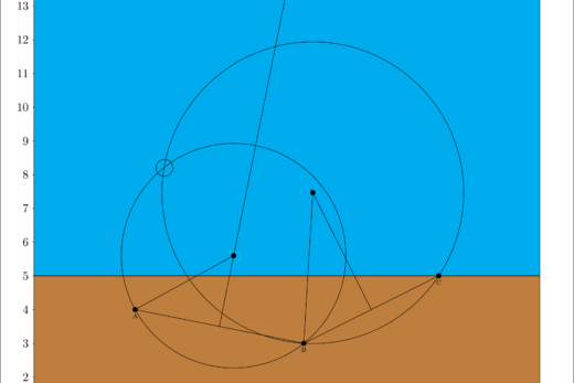
Together with the estimated position, this information provides everything needed to plot the position lines.
Plotting position lines
The position lines are plotted in the image below. To make it easier to read on screen, the position triangle is drawn in pen. The ship’s position is 44° 1.0′ N / 055° 54.0′ W.
Conclusion
The exercise above incorporates all aspects of an astronomical position fix. It can be seen that taking three star sightings amounts to repeating the procedure outlined three times. In this regard, once the subject matter is well understood, it becomes convenient to develop spreadsheets to facilitate the serial calculation of the intermediate steps.
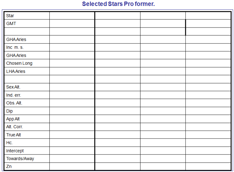
The tables presented in this exercise are a good example of ‘serial calculation’, but are nevertheless limited by the layout options of this website. On paper, there are numerous worksheets available for reducing observations concisely. A sample spreadsheet is provided below, but a quick search online will reveal other formats.
In the exercise, the observations are all taken at exactly the same time. This is somewhat artificial. In practice, observations differ by a few minutes, meaning that the position of the stars is no longer the same. The calculation method remains the same, but if the ship is moving, the estimated position of the ship will change and therefore the position lines will start from different points. Simplified in this way, the exercise avoids the need to discuss the transposition of position lines (a ‘running fix’). If the times of the sightings differ, one would transpose the position lines so that they are all at the same time, thereby increasing the accuracy of the position.
In the final text of this series, we will cover the method for determining a position using two solar observations taken at different times (known as ‘sun-run-sun’). This method makes explicit use of transposed position lines. If necessary, it is useful to revise this concept before applying it.
Did you enjoy this article? You can continue reading the series on astronomical navigation. You can also read other articles in the Learn section of this site.